|
This script was written by Ian Rivard, to delete non-deletable coordinate systems. It is currently in draft - alpha, but is included in the standard FEMAP API suite from engineeringtools.org. Ian is looking for feedback on this tool, if you ever have a case where it doesn't delete a coordinate system for you, send him a zip of the bulk deck and indicate which coordinate system it doesn't work on. This will help improve the robustness of the tool. Background: In Femap, or other codes, Coordinate Systems are referenced by other entities. In the model info tree if you expand the coordinate systems, you can right click on a coordinate system and choose "list"
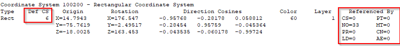
This will then list to the messages window something like the following:
on the right side, in the red box, you can see a listing of the entities that reference this coordinate system. In this case NO=33 is listed. This means that there are 33 nodes that reference this coordinate system. It would be a non-deletable coordinate system then, because there are entities that reference it. In order to delete it that dependency needs to be removed. IE those 33 nodes need to be edited to reference a different coordinate system. On the left side you can see that this coordinate system is defined based on coordinate system 6. Coordinate system 6, therefore, can't be deleted because this one references it. decoding the message:
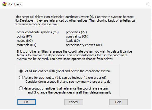
The current version of the script presents three options as follows:
The first option replaces instances of the coordinate system to be deleted with the global coordinate system. This is the easiest solution to implement in a loop, and can modify a lot of entities very quickly and efficiently. However, replacing with global might not be a good solution depending on the model, if fact it probably isn't a good solution for anything more complicated than a simple complexity model. The next option will loop through, and prompt the user with an edit gui at each instance. This can be a great solution if there aren't many things to change, but if you have more than just a couple to do this option can be very long and tedious - so only use as appropriate. The third option will make a group of entities that reference the coordinate system to be deleted and the user can then review and re-assign them as appropriate. This is the most flexible and recommended option. Remember: It is currently in draft - alpha. Ian is looking for feedback on this tool, if you ever have a case where it doesn't work properly for you, send him a zip of the bulk deck and indicate which coordinate system it doesn't work on. This will help improve the robustness of the tool. |
||||